

24d12'S, 27d58'E
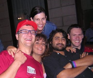
This is my Aussie pal, Christian (far left) with his girlfriend Kate (top), cousin Corrado (far right) and our friend Amanda; on his farewell evening.
 Now, Chris & Kate went on a touristy trip to Barcelona, and some random guy in the metro gave him a t-shirt, which he gave me.
This t-shirt says South Africa and has a coordinate. So naturally I stuck the coordinates in Google Earth. Here's what comes up:
Now, Chris & Kate went on a touristy trip to Barcelona, and some random guy in the metro gave him a t-shirt, which he gave me.
This t-shirt says South Africa and has a coordinate. So naturally I stuck the coordinates in Google Earth. Here's what comes up:
 Any clues to what it could be are appreciated!
(ps: the white line about a third of the way down and a little over halfway across the pic is 1km in length, so the scale is clear)....
bizzare
Any clues to what it could be are appreciated!
(ps: the white line about a third of the way down and a little over halfway across the pic is 1km in length, so the scale is clear)....
bizzare
posted by mohinish | 5:57 PM
![]()
![]()
3 Comments:
Mo,this area seems to be mostly Agricultural,most of the names there are of Farmsteads.I guess the circles are fields,with a rotating arm used to irrigate them.
Possible. But then there don't seem to be farmhouses around. In fact there doesn't seem to be any settlements for miles around.
And why round?
And why are some of them only half-green?
I think the resolution of that area is too low to show farmhouses.. maybe the farmhouses are not actully near the farms, but in the town nearby.
Round fields would make sense for an irrigation boom.. you would need a motor only at one point to rotate the arm.
The color difference could be because of two different crops..
Post a Comment
<< Home